
Marine Plotter,7in Marine Plotter Built Boat Navigation Positioner Marine GPS Locator Finest Materials
GRATIS verzending


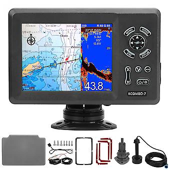
Marine Plotter,7in Marine Plotter Built Boat Navigation Positioner Marine GPS Locator Finest Materials
- Merk: Unbranded
Marine Plotter,7in Marine Plotter Built Boat Navigation Positioner Marine GPS Locator Finest Materials
- Merk: Unbranded
Bespaar € 1.150,00 (42%)
Adviesprijs
Bespaar € 1.150,00 (42%)
Adviesprijs
We accepteren de volgende betalingsmethoden
Beschrijving
- Merk: Unbranded
- Categorie: Kaartplotters en GPS voor boten
- Fruugo-ID: 278693204-619784808
- EAN: 9797733645950
Levering & retouren
Verzonden binnen10 dagen
-
EXPRESS: GRATIS - Levering tussen ma 01 december 2025–di 02 december 2025 - GRATIS - Snelst
-
STANDARD: GRATIS - Levering tussen ma 08 december 2025–ma 15 december 2025 - GRATIS
Verzending vanaf China.
We doen ons best om ervoor te zorgen dat de producten die u bestelt volledig en volgens uw specificaties bij u worden afgeleverd. Mocht u echter een onvolledige bestelling ontvangen of andere artikelen dan degene die u heeft besteld, of als er een andere reden is waarom u niet tevreden bent met de bestelling, dan kunt u de bestelling retourneren, of welk product dan ook die bij de bestelling was inbegrepen, en ontvangt u een volledige terugbetaling voor de artikelen. Bekijk het volledige retourbeleid